Nepal Parliament's Approves New Controversial Map, India Rejects It But ......

The Upper House of the Nepali Parliament on Sunday (14 June) approved the proposal to discuss the Constitution Amendment Bill to update the country's new political map. These maps cover three strategically important Indian regions. A day earlier, the lower house had unanimously voted in favor of the resolution.
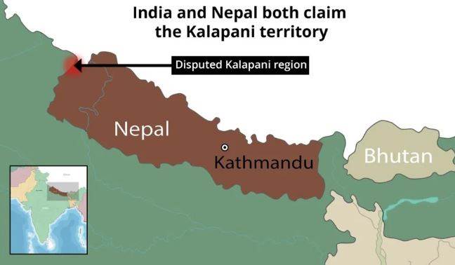
Nepal's ruling and opposition political parties on Saturday (June 13) voted in favor of a government bill amending the Third Schedule of the Constitution to update the national symbol to include the newly disputed map. Under this, Lipulekh, Kalapani and Limpiyadhura, located in Uttarakhand, India, are shown as Nepali territory. India strongly opposed the move and said it was not acceptable.
On Saturday (June 13), all 258 MPs present in the lower house of Nepal voted in favor of the amendment bill. There was not a single opinion against the motion. Now the Bill will have to go through the same process again in the National Assembly. The ruling Nepal Communist Party has a two-thirds majority in the National Assembly.
According to a news from the newspaper Kathmandu Post, Rajendra Fuyal, Secretary of the National Assembly Secretariat, introduced the bill in the first sitting of the House on Sunday. According to the newspaper, during the second meeting of the National Assembly later on Sunday, Law Minister Shivamaya Tumbahamphe moved a proposal for consideration of the bill. It said that after discussion, the proposal to consider the Bill was unanimously accepted.
The National Assembly has given MPs 72 hours to present amendments to the provisions of the Bill. Quoting Fuyad, the newspaper said, "We are making necessary preparations to pass the bill in the next four days." Voting on the matter is formally scheduled for Tuesday (June 16) in the Upper House of Nepal. After passing from the National Assembly, the bill will go to the President for signature. After his signature, it will be included in the Constitution and this map will be used again in every government document.
Meanwhile another news outlet the Himalayan Times reported that the main opposition party, the Nepali Congress, has requested the government to speed up the diplomatic effort to ensure that the country has the right in the Kalapani area after updating its political and administrative map.
READ HERE MORE : Rayshard Brooks Murder Case : Is Apartheid Back In USA ?
Foreign Ministry spokesman Anurag Shrivastava said in his statement on Saturday that we have seen the Constitution amendment bill being passed by Nepal in the House of Representatives to make changes to the new map and to include some Indian territory.
We have already made our position clear in this matter. He stated that the artificially detailed detail under the claims is not based on evidence and historical facts and is not valid.
Relations between India and Nepal were strained when Defense Minister Rajnath Singh inaugurated a strategically important 80-km road connecting Dharchula to Lipulekh Pass in Uttarakhand on 8 May.
Nepal reacted sharply to the opening of this road, claiming that the road passes through the Nepali region. India rejected Nepal's claims, reiterating that the road was completely located in its territory.
Nepal released its revised political and administrative map of the country last month, stating its claim on these strategically important areas. India has been saying that these three areas belong to it. On the release of the new map by Kathmandu, India had strongly warned Nepal not to attempt to "artificially exaggerate" regional claims.
India on Saturday rejected the passed Constitution Amendment Bill related to Nepal's changes to the map and the inclusion of some Indian territory by the lower house of parliament, saying that this artificial extension is not based on evidence and historical facts and is valid Is not. India has said that it is also a violation of our current understanding of resolving pending border issues through dialogue.
Foreign Ministry spokesman Anurag Shrivastava said in his statement, "We have seen the passage of the Constitution Amendment Bill by Nepal to make changes to the new map and to include some Indian territories in the House of Representatives there." We have already made our position clear in this matter."
At the same time, Army Chief General MM Narwane had said that there are reasons to believe that Nepal has opposed the road at the behest of someone else, he said this while possibly referring to China's role in the subject.
Nepal is clearly playing in the hands of the Communist regime of China as the Communist Party of Nepal is the agent of China and will never shy to lick the boots of its master Xi Jinping. India is not in a mood to compromise and let Nepal do what it feels like while maintaining its old policy of not taking offence but if the once Hindu-Rashtra Nepal thinks it can do any harm to India then our nation would be the first country to break it's hallucination.
In the worst of the scenario, we can see Bihar-Nepal getting sealed and turned into a war zone with cross-firing from both sides. Now it is time for them to decide whether they wanna go in cold war or real war If they are truly a Communist state in real to be precise. For now, India has rejected their claim on Lipulekh, Kalapani, Limpiyadhura but has not ended the relations with it. So Nepal has entered into a self-made stalemate of relations
I am a content writter !